Mallee seeps
- Fact sheet
- November 2015

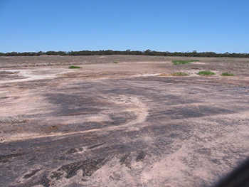
salt crystals and black anaerobic staining at the soil surface.
What is a mallee seep?
Mallee seeps are damp, usually saline, areas found in the low swales of sand dunes where the water table is coming to the soil surface.
Mallee seeps form unpredictably and they can appear in the landscape without any apparent cause.
They often form in low lying depressions where groundwater is slowly discharged at the soil surface but they can also occur on hillsides and at break of slope in larger dunes.
It is thought that control of summer weeds on sand hills, a result of modern farming techniques and the use of herbicides within continuous cropping systems, may have created excess water in the landscape.
Excess water drains through the deep sands of dunes, forming a shallow water table on top of or within the impermeable clay sub-soils.
Improved understanding of the causes and processes producing seeps will lead to more effective management and use of these areas.
A project to define the causes, processes and best practice methods of managing and rehabilitating mallee seeps is being supported by the Murraylands and Riverland Landscape Board through funding from the Australian Government's National Landcare Program.
This project includes intensive investigation and monitoring of the landscape and soils at two sites and the establishment of trials to determine suitable agronomic and environmental options.
The aim is to assist farmers, land management advisors and agronomists to improve their knowledge of seep formation processes and provide information on options for how to best manage problem seeps.
Case Study - Wynarka
The site at Wynarka was cleared between 1905 and 1910 but the seep problem was first noticed around 2005. The land, although tending to be boggy, grew good crops up to about 2008 when production began to noticeably decline
By 2011 the area was too wet to drive on and had gradually turned saline. The ground is now bare and scalded with visible mineral salt crystals (Figure 1).
The surrounding area is too soft for machinery to be driven over for most of the year and cannot be sown to crops or pasture.
No plants are growing on the most severely affected areas while rye-grass, brome, and thistles grow prolifically on the fringes of the seep.
The surrounding sand dunes are formed of non-wetting white sandy soil that sustains very poor plant growth so subsoil moisture is not used to its full extent.
Aerial photographs revealed that the closed depressions where seeps had formed seemed to be blocked by slightly raised calcrete bench areas, both in the study area and in an adjacent area.

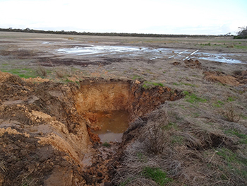
Figure 2 – A soil pit at the margin of the seep revealed very poor drainage.
Soil testing from the dune crest to a lower dune slope revealed a sandy to sandy loam, inherently infertile top soil.
Subsoils range from light sandy clay loams to medium clays. The brown and mottled colouration indicates internal soil drainage is poor.
It was observed that just after the pit was excavated, water began to trickle in from the top of the clay layer.
Water also entered via a crack in the pit face 1 metre down. After one day the excavated hole was half full of water.
Deep drilling revealed saturated layers upon underlying heavy, tight mottled clay at all three sites, even the dune crest.
Drilling found that the main water-bearing system was at depth (e.g. about 6 metres below the dune crest), and that the tight mottled clay (probably Blanchetown Clay) forms the base of this system.
The site at the lower slope possesses more poorly drained subsoil layers because of its greater clay content, as well as the presence of a thin calcrete layer and dispersive clays. The presence of bleached top soil confirms this.
Reference: Hall JA (2015) Mallee Dune Seeps. Soil Characterisation and Land Unit Mapping.