Healthy Soils, Healthy Landscapes outcomes report
Since 2018, Landscapes Hills and Fleurieu, has been working to deliver the Healthy Soils, Healthy Landscapes project across farms in the old footprint of the Adelaide and Mt Lofty Ranges (AMLR) NRM region. The project set out to deliver soil information through soil testing and to advise farmers of management strategies they could use on their properties to improve soil health.
Healthy Soils, Healthy Landscapes
The 5-year project was funded under phase 2 of the Australian Government’s National Landcare Program. Its aim was to work with farmers, agricultural industry and community groups to improve soil health by focussing on soil pH, carbon and erosion. The desired long-term outcome was to boost the region’s agricultural productivity and profitability as well as the natural resource base on which it depends.
Soil acidity (low pH)
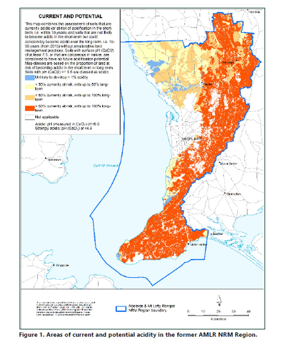
Soil acidity was identified as the major natural resource threat to agriculture in the region. Acidification rates are estimated to be increasing over time, due to increasing agricultural production, particularly in areas with more intensive cropping systems and higher nitrogen inputs.
See figure 1 showing area of current and potential acidity in the AMLR region.

Long term soil monitoring
To monitor this increase in acidity, long term monitoring sites were established where surface and subsoil pH were monitored over the course of the 5 years.
Thirty-one soil acidity sites were also established during the 2018 -19 and 2019 -20 financial years throughout the Adelaide Mount Lofty Ranges NRM district. Twenty were selected based on previous monitoring data, while the rest (eleven), were new sites. These included five in the Lower North district, where acidity had only recently emerged.
Sites were selected based on past site data and to give a good coverage of the AMLR footprint. Six sites were located in the Fleurieu Peninsula and 19 were located throughout the Barossa and Mount Lofty Ranges. All the sites chosen were accessible, sampled to at least 30 cm soil depth and had landowner permission to sample and to publish soil test results (without prejudice to the landholder). All sites had some site history available and were not on the SA Register of Aboriginal Sites and Objects.
Twenty-five of these sites were selected to re-sample and the soil data was compared to initial data.
The site sampling depths minimum was 0-30 cm and up to 100cm deep depending on the capability of the machinery.
There were three key findings from the monitoring sites. These were that
- Surface pH improved where the soil was limed but there was no consistent effect on sub-surface pH.
- Un-limed sites showed mixed results, with some sites improving and some getting worse.
- In general, limed sites were better (decrease in soil acidity) than un-limed sites (increase in soil acidity).
Landholder soil testing
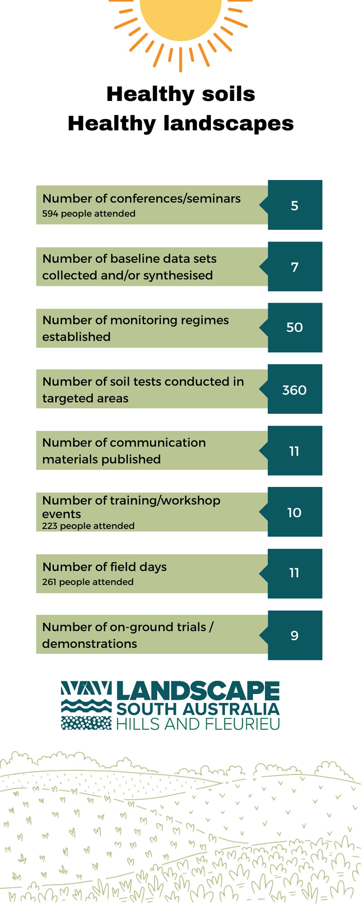
In addition to the 25 long term monitoring sites, 360 free soil tests were conducted for landholders within the region, 100 of which were re-sampling sites tested earlier in the project to monitor any change. For each test, the landholder received a free customised soil report which identified any constraints and recommended possible actions to correct them.
Trial sites
To assess the efficacy of liming and other soil ameliorants, three trial sites were established across the region where different soil treatments were compared.
At the Mallala site, a variety of lime rates and other soil ameliorations suspected to effect pH were plot trialled within a commercial cropping environment.
Increasing liming rates showed increasing improvements in pH and crop yield, and importantly, these effects continued or increased with time throughout the trial.
Organic amendments including compost and chicken manure showed improvements in the first few years, but the effect dropped off over time.
At the Birdwood site, a number of different lime rates and other amendments were trialled in a similar way to the Mallala site, but this time, in a pasture setting. The results were consistent with the Mallala site, with lime showing improvements in pH and pasture growth, while the other amendments did not.
At the Myponga site, variable rate lime application was trialled. Due to the high acidity of the soil, the entire property required the maximum application level (3 t/ha). However, when the property was re-mapped 2 years later, significant sections of the property did not require a second treatment, resulting in significant cost savings for the landowner.
Summary of soil sampling and trial sites
The project’s results demonstrated the need for liming across most sites. Although soil acidification is an issue in the region, regular treatment with lime or other soil treatments (such as clay spreading or adding organic matter in the form of compost) can reduce soil acidification in surface soils.
Liming programs need to be carried out over long periods of time to be genuinely effective in combatting soil acidification.
Workshops and conferences
To help farmers and Ag-industry representatives understand the importance of soil acidity, soil carbon and erosion, the project:
- sponsored five local conferences and seminars attended by 594 people in total
- ran ten training events or workshops attended by 223 people in total, and
- held eleven field days attended by 261 people in total.
Lime sales
To determine the impact the project was having across the region, lime use in the region was monitored. It was found that from 2018 to 2022, lime use in the former Adelaide and Mt Lofty Ranges (AMLR) region had increased slightly from 14,000 to 18,000 tonnes. In the Central Hills and Fleurieu agricultural district, annual lime use had mostly been around or above the estimated lime requirement, including the 2018 -2022 period. In contrast, lime use in the Lower North district had been well below the lime requirement since 1999, although it has increased sharply since the start of the project to be roughly equal to the lime requirement in 2022.
Plant growth results
To further assess the outcomes for landholders, plant growth across the region was analysed using MODIS satellite data.
Since 2001 in the Central Hills and Fleurieu district, there has been an increasing trend in annual mean plant growth, but not any significant change in annual rainfall. In the Lower North, plant growth has increased, while there has been a slight decline in annual rainfall. This indicates that overall, plant growth has increased slightly across the AMLR NRM region relative to annual rainfall over this period. On agricultural cropping and grazing land, this could be the result of improved agronomy, soil management and grazing management over this period.
Future
Looking to the future, the project team advised that re-sampling of sites within ten years is important as well as ensuring landholders are educated on the impacts of acidification. They also suggested that the project area should be expanded to include sites such as Mount Baker, Meadows and Currency Creek, to gain a wider understanding of the extent of soil acidification across the region.
The team recommended that additional focus should target alternative products that are being utilised to combat soil acidification within the Adelaide and Mount Lofty Ranges regions, such as spreading clay and organic matter. All data captured by the project was entered into the DEW soil database, ensuring good soil data is maintained for future studies.

This project was delivered by Landscapes Hills and Fleurieu, with the support from the Northern and Yorke Landscape Board, SARDI/PIRSA and the Australian Government’s National Landcare program.
